China Top 10 Ports for Global Maritime Trade?
China’s ports connect factories, farms, and inland cities with customers across the world. In global maritime trade, their role is visible in more than container totals. Deep-water channels, rail links, customs processes, and nearby industrial zones all shape how cargo moves. A ship arriving off Shanghai or Ningbo-Zhoushan is only one part of a much larger transport network.
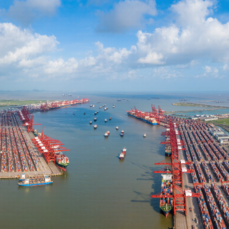
This guide explores ten major Chinese ports, including Shanghai, Ningbo-Zhoushan, Shenzhen, Qingdao, Guangzhou, Tianjin, Xiamen, and Dalian. Each serves a different mix of routes and industries. At some terminals, cranes lift containers from vessels while trucks queue beyond the gates. Other port areas handle bulk commodities, energy products, or regional feeder services. The details matter.
Port rankings can change with the year and the measure used. Container throughput, total cargo tonnage, and international connectivity do not produce identical lists. So a “top ten” selection is useful, but never perfectly simple. A port with huge cargo volumes may not be the best fit for every shipment, and published statistics can lag behind current operations. Readers should check recent port data when making business decisions. This overview provides context rather than a substitute for route-specific research. It looks at what makes these gateways influential, where their strengths differ, and why China’s maritime network remains central to trade across Asia and beyond.
How China’s Major Ports Are Ranked
China’s major ports are not ranked by one universal score. Most top-port lists use annual container throughput, measured in TEUs, to compare handling volumes. Shanghai, Ningbo-Zhoushan, Shenzhen, Qingdao, Guangzhou, and Tianjin regularly appear among the country’s leading ports. Their exact order can change by year and data source.
Other rankings measure total cargo tonnage, shipping connectivity, vessel turnaround, or links to inland rail and road networks. These indicators tell different stories. A bulk-cargo port may lead by tonnage, while a container hub ranks higher by TEUs. Check whether figures cover an entire port or one terminal, and compare the same calendar year. Data can be revised, too. Rankings are useful, but not perfectly tidy.
Tips: Note the metric, year, and source before citing a top-ten list. For practical planning, compare route frequency and inland access as well. A high rank alone does not guarantee a suitable service.
The Top 10 Ports in China’s Maritime Trade Network
China’s maritime network is not one harbor with ten names. It is a chain of coastal gateways linking factories, inland transport, and overseas markets. Shanghai and Ningbo-Zhoushan handle enormous container flows near the Yangtze River Delta. Shenzhen and Guangzhou serve manufacturing centers in the south, while Qingdao and Tianjin connect northern industries with global routes.
A useful top-ten overview also includes Xiamen, Dalian, Lianyungang, and Yingkou. Their relative positions depend on the measure used: container volume, total cargo tonnage, or annual growth. Rankings shift. That distinction matters when comparing ports. A container terminal may look busy from the quay, with cranes moving boxes through the night, yet bulk cargo figures tell a different story.
These ports work as connected logistics hubs, not isolated loading points. Rail links, warehouses, customs capacity, and nearby industrial zones can influence how quickly goods reach a ship. Port performance can also change with seasonal demand and shipping schedules. Numbers alone miss some of that. And no ranking stays perfect for long; this overview is a useful map, not a fixed league table.
Where China’s Leading Ports Are Located
China’s leading ports are spread across three busy coastal zones. Shanghai sits at the Yangtze River estuary, linking the East China Sea with the country’s inland river network. The Ministry of Transport’s 2023 port statistics recorded about 49.2 million TEU there. Further south, Ningbo-Zhoushan faces the East China Sea in Zhejiang province and handled roughly 35.3 million TEU. Shenzhen lies on the Pearl River estuary, across from Hong Kong; its terminals processed about 30 million TEU. These figures show scale, but not the full journey of cargo inland.
The northern coastline has another major cluster. Qingdao is in Shandong, Tianjin serves the Beijing region through Bohai Bay, and Dalian occupies the Liaodong Peninsula. Farther south, Guangzhou sits upriver in the Pearl River Delta, while Xiamen faces the Taiwan Strait in Fujian. Suzhou’s port facilities connect the Yangtze Delta’s manufacturing belt with coastal shipping, and Beibu Gulf port serves Guangxi on the southwest coast. The Ministry’s 2023 data places these ports among China’s leading container gateways. Geography matters. Yet a coastal map can hide inland rail links, river access, and differences between port areas. I would not treat port location alone as a measure of shipping convenience.
China’s Top 10 Ports for Global Maritime Trade
Where China’s leading container ports are located, ranked by 2022 throughput.
Shanghai leads the ranking, followed by Ningbo-Zhoushan and Shenzhen. Throughput is shown in millions of TEUs (twenty-foot equivalent units); figures are rounded. Hong Kong is listed as a separate port region. Data compiled from port authority and municipal statistical reports.
Key Cargo Types and Shipping Routes
China’s major maritime ports handle distinct cargo mixes. Shanghai and Ningbo-Zhoushan move vast container volumes, alongside machinery, consumer goods, and bulk cargo. Shenzhen and Guangzhou connect southern manufacturing centers with regional and trans-Pacific services. Qingdao handles containers, iron ore, and agricultural products, while Tianjin serves northern industrial supply chains. Dalian, Yingkou, Xiamen, and Lianyungang add capacity for energy, grain, vehicles, and factory goods. Cargo patterns vary by terminal and season.
Routes depend on the shipment. Container vessels from eastern ports serve destinations across Northeast and Southeast Asia, then connect with longer routes to Europe and North America. Many Europe-bound services travel through the South China Sea and Suez Canal; trans-Pacific routes cross the Pacific toward North American ports. Some cargo moves differently: ore, coal, and grain often use specialized terminals and bulk carriers. Small details matter. A late feeder vessel or crowded yard can reshape a schedule, even when the route looks simple on a map. Real port operations are less tidy than the diagrams.
How Port Infrastructure Supports Global Trade
China’s major ports, including Shanghai, Ningbo-Zhoushan, Shenzhen, and Qingdao, connect manufacturers and consumers to ocean routes. Their value is not measured by container volume alone. Deep channels accommodate larger vessels, while quay cranes transfer containers between ships and terminals. Nearby rail yards and highways then carry cargo inland. When these links work together, ships spend less time waiting and businesses can plan inventory with greater confidence. Yet a port can look efficient from the water while congestion builds on nearby roads. That matters.
Reliable infrastructure depends on more than concrete and steel. Digital scheduling can help terminals assign berths and equipment, while accurate cargo data may prevent avoidable delays. Regular dredging, safe navigation systems, and resilient power support operations during heavy traffic and rough weather. Still, technology cannot fix every bottleneck. A rail disruption or staffing gap can slow cargo across the supply chain. Routine maintenance, trained workers, and coordination with inland transport are less visible, but they shape how dependable trade feels. Ports also need to review what is not working; improvement is rarely finished.
Tips: Compare ports using more than annual throughput. Check vessel waiting times, rail connections, weather resilience, and cargo clearance speed. Ask where congestion moves after containers leave the terminal.